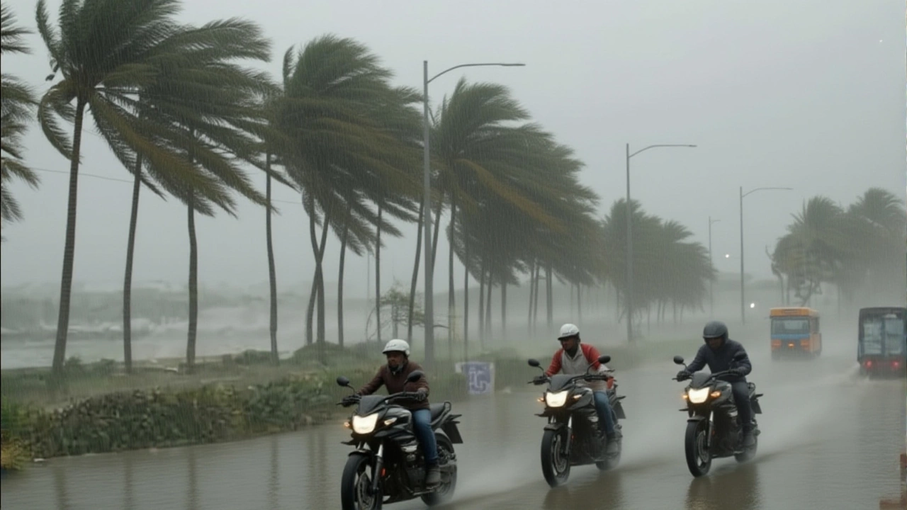
On the evening of October 28, 2025, Cyclonic Storm Montha slammed into the coast between Machilipatnam and Kalingapatnam in Andhra Pradesh, India, with wind speeds hitting 98 km/h and a 1.1-meter storm surge drowning low-lying neighborhoods. The India Meteorological Department (IMD) had warned for days — and now, the forecast had become reality. Schools were closed, trains halted, and flights grounded. Coastal residents, many of whom had spent the night sandbagging doors and boarding windows, braced for the worst. And it came — hard and fast.
From Tropical Disturbance to Severe Storm
Cyclonic Storm Montha didn’t start as a monster. It began as a disorganized cluster of thunderstorms over the southern Bay of Bengal on October 26, 2025. By the next day, the Joint Typhoon Warning Center (JTWC) had classified it as a tropical storm, with winds of 85 km/h. What followed was rapid intensification — fueled by sea surface temperatures of 29.5°C, unusually warm for late October. The IMD upgraded it to a severe cyclonic storm by 6 a.m. on October 28, just hours before landfall.The storm’s track was eerily predictable. Guided by a stubborn subtropical ridge to the northeast, it moved steadily northwest at 9 km/h, a pace that gave authorities just enough time — but not much more — to prepare. Models from the European Centre for Medium-Range Weather Forecasts (ECMWF) and the Global Forecast System (GFS) agreed within 15 kilometers of each other on the landfall point. That kind of consensus is rare. And it’s why the response was so coordinated.
Evacuations, Cancellations, and Emergency Mobilization
Over 3,000 people were evacuated from coastal villages in Odisha and Andhra Pradesh. In Visakhapatnam, the state’s largest port city, IndiGo and Air India Express grounded all flights. Fourty-three trains scheduled to pass through the city were canceled. The Visakhapatnam Airport recorded zero departures for 24 hours — the first time since 2018.
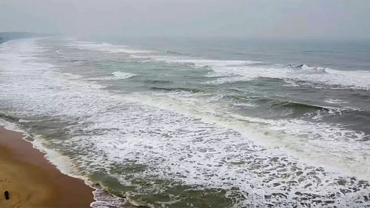
In Chennai, Rashmi Siddharth Zagade, the District Collector, declared a holiday for all schools on October 28 after rainfall exceeded 120 mm in just six hours. The Greater Chennai Corporation deployed 23,000 personnel to 160 flood-prone zones. At Marina Beach, waves crashed over sea walls — a sight locals haven’t seen since Cyclone Gaja in 2018.
Andhra Pradesh’s Chief Minister, YS Jagan Mohan Reddy, held an emergency meeting at the State Emergency Operations Center in Amaravati at 2 p.m. on October 27. “We are not waiting for disaster,” he told reporters. “We are moving before it hits.” His team had pre-positioned 120 Disaster Response Force (DRF) teams, 47 water rescue boats, and 800 tons of food rations.
What the Storm Left Behind
By 11 p.m. on October 28, Cyclone Montha had made landfall near Kakinada. Wind gusts peaked at 112 km/h, tearing roofs off homes in Kothapeta and flooding streets in Narsapuram. The IMD recorded 187 mm of rain in East Godavari district — the highest in 15 years for this time of year. Storm surges of 1.2 meters submerged coastal roads, cutting off access to three villages near Kalingapatnam.
Power outages affected over 1.2 million households across Andhra Pradesh and northern Tamil Nadu. Mobile networks went down in 17 blocks. The Andhra Pradesh Maritime Board shut down all ports from Visakhapatnam to Kakinada — a decision that cost an estimated $2.3 million in lost shipping activity over 48 hours.
By dawn on October 29, the system had weakened to a deep depression. But the damage was done. Early reports from district collectors indicate 11 fatalities, mostly from collapsing walls and electrocution. Over 1,700 homes were damaged. The real toll, officials warn, won’t be known until water recedes.
Why This Storm Matters
This wasn’t just another cyclone. It was the 27th named storm in the Bay of Bengal since 2020 — and the third in 2025 alone. Climate scientists point to warming waters as the engine behind this trend. The Bay’s average temperature has risen 0.8°C since 2010. That may sound small, but it’s enough to supercharge storms.
“We used to see severe cyclones every three to four years,” said Dr. Anjali Sharma, a meteorologist at the Indian Institute of Tropical Meteorology. “Now, we’re seeing them every 12 to 18 months. The pattern is clear.”
And the human cost? It’s growing. In 2020, Cyclone Amphan killed over 100 people. In 2023, Cyclone Biparjoy claimed 32. Montha’s death toll is lower — thanks to better forecasting, earlier evacuations, and stronger infrastructure. But the number of people affected? It’s higher than ever.
What’s Next?
The IMD says Cyclone Montha will dissipate completely by October 30. But recovery is just beginning. The National Disaster Response Force is now shifting from rescue to relief. Food, clean water, and temporary shelters are being airlifted. Power restoration teams are working around the clock.
Meanwhile, political pressure is mounting. Opposition leaders are demanding a national disaster relief package. The central government has promised an assessment team by November 2. But for now, families in Kakinada and Machilipatnam are picking up shattered tiles, drying out soaked books, and wondering when — or if — their lives will return to normal.
Frequently Asked Questions
How did Cyclone Montha get its name?
The name ‘Montha’ was contributed by Bangladesh as part of the rotating North Indian Ocean cyclone naming list managed by the India Meteorological Department. Names are chosen from a pool of 169 submitted by eight regional countries and reused every few years unless retired after a particularly deadly storm. ‘Montha’ means ‘moon’ in Bengali, symbolizing calm — a cruel irony given the storm’s fury.
Why was the storm’s path so predictable?
The subtropical ridge — a high-pressure system — acted like a wall, forcing Montha to move steadily northwest. Both the GFS and ECMWF models showed near-identical tracks, giving forecasters 95% confidence in landfall location. This level of agreement is rare and reflects improved global modeling and satellite data, especially from India’s INSAT-3DR and NASA’s GOES satellites.
What impact did the storm have on Chennai despite being far from landfall?
Even though Montha made landfall 600 km away, its outer rainbands dumped over 150 mm of rain on Chennai in under 12 hours. The city’s aging drainage system, already strained by urbanization, couldn’t handle the deluge. Flooding paralyzed traffic, submerged metro stations, and disrupted power. The IMD had warned of this ‘remote impact’ — a growing pattern as cyclones grow larger and wetter.
Why were so many trains canceled?
Indian Railways canceled 43 trains through Visakhapatnam because tracks near the coast were at risk of washouts. Heavy rainfall saturated the soil, making embankments unstable. Additionally, overhead power lines were swaying dangerously in 90+ km/h winds. Railways prioritize safety over schedule — especially after the 2022 Odisha train derailment, which was linked to storm damage.
Is this the new normal for the Bay of Bengal?
Yes. Since 2020, the Bay of Bengal has produced 27 cyclones — double the average from 1990–2019. Warmer waters, higher humidity, and weaker wind shear are creating ideal conditions for rapid intensification. Scientists warn that by 2040, severe cyclones like Montha could occur every 6–8 months in peak season. Adaptation isn’t optional — it’s urgent.
What’s being done to protect coastal communities long-term?
The National Disaster Management Authority has approved ₹850 crore ($100 million) for coastal embankments, early warning sirens, and elevated shelters in 12 vulnerable districts. Andhra Pradesh is building 120 multi-purpose cyclone shelters by 2027. But experts say funding alone isn’t enough. Community training, fisherfolk education, and mangrove restoration are critical — and underfunded. The real solution lies in integrating traditional knowledge with modern tech.